Solar Energy Plant Development Using GIS
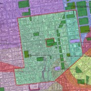
 GIS is a powerful tool that makes it easy to collect, store, manipulate, analyze and display accurate information in a geographically organized manner. Using this geographically referenced data, clients can visualize trends, patterns and relationships in the data so they compare the suitability of multiple locations for solar energy plant development.
Using GIS for Renewable Energy Projects
GIS maps begin as simple geographic maps, but they become so much more. We can add an infinite number of datasets to the base map, creating multiple layers of information. Then, we make the maps interactive so you can easily look into specific information for your project, while not losing track of the big picture. GIS plays a critical role in placing solar energy plant projects by allowing planning commissions, policymakers and others to decide which locations are best for developing solar energy with the least amount of impact on the population.
Applications of GIS Data for Solar Projects
This tool also reduces the environmental and social impact of solar energy plant projects. By displaying spatial variables in an easy-to-understand manner a GIS map can help project managers avoid major project complications. GIS can make it more apparent when there are patterns in the data and highlight details that may have been overlooked when seen in a less coordinated fashion.
For example, with the ability to view multiple datasets in just one GIS map, project planners can compare historical ambient temperatures and solar radiation levels in various locations. This allows them to select optimal locations for a solar energy plant’s location.
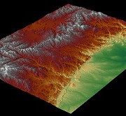
Through the map, users can calculate the solar radiation available on building rooftops, build digital elevation models and analyze the effect changes in orientation, elevation, and topographical features. Easy-to-use web-based GIS maps take this data and present the logistics of solar energy investment to everyone who needs access. With these web-maps companies can display and share large amounts of data across departments or even between organizations so everyone has a chance to use the data to come up with the best solution.
The Importance of GIS for Solar Projects
This simple yet powerful tool has an intuitive interface that changes the way we view solar energy and opens the door for larger, more widespread projects. Using GIS for renewable energy projects improves the way we deliver and produce energy and supports the development of cleaner, smarter and more eco-friendly methods of energy production. To learn more about how Landpoint and GIS Mapping can bring success to your energy project, contact us today.
Image By: pgegreenenergy

